
 01
01Detail · Feature · Level · Contour
Detail, Feature & Level Surveys in Sydney.
The site plan your architect, engineer and council need before a single line gets drawn. Registered surveyors, fixed prices, plans in days.
What it is
One survey, the whole picture of your block.
Our team of registered surveyors is dedicated to delivering highly accurate detail surveys, which are essential for making informed decisions throughout every development phase, from initial planning to final construction.
Topographic survey, feature and level survey, contour survey, site survey: different words, same job. Here is how the pieces fit together.

Contour survey
Maps the natural surface levels of a property, showing elevation changes through contour lines.Detail / feature survey
Contour plus visible features: buildings, fences, trees, utilities and roads. The full site map.Level survey
Reduced levels tied to datum, so drainage, floor heights and earthworks all start from the same point.
When you need one
Almost every property project starts here.
If you are designing, approving or building anything on your land, this is the survey that comes first.
DA submissions
Councils across Sydney require a detail and level survey with most development applications. Renovations and extensions: design from measured levels, not assumptions.
New builds
Contours and levels for siting, drainage, earthworks and setbacks.Subdivisions
Feasibility and planning both start from an accurate site plan of the whole property.Pools & landscaping
Levels, trees and services mapped properly before anyone excavates. Due diligence: know what is actually on the land before you commit.
What's included
What you get, and when.
One site visit, one plan, everything your architect, engineer and council need to work from.
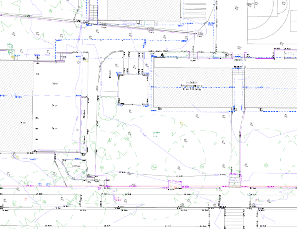 Sample plan extract, 1:200
Captured in the field
8 standard inclusionsSomething specific your consultant needs picked up? Tell us when you request your quote and we will include it.
Why Surveyland
Measured properly, priced honestly.
Registered surveyors
Every plan signed off by a registered NSW surveyor you can verify on the BOSSI register.Current technology
Robotic total stations, GNSS and laser scanning, so more detail in fewer site visits.Fast, fixed and clear
A fixed price back the same day, and plans your consultants can work from immediately.What our clients say.
“Very responsive, friendly, good value. Happy to recommend!”
“They gave a fair price and the work provided was excellent quality. They were also really nice people with great communication skills.”
“Dylan was very prompt at attending to the job, he arrived the next day and worked through the rain to complete it. I was very impressed.”
No jargon
Common questions.
Straight answers on detail, feature and level surveys. Anything we have not covered, just call.
1300 575 702A contour survey maps the natural surface levels of a property, showing elevation changes through contour lines. A boundary survey determines the exact legal property lines and corner positions. A detail survey provides both contour and visible features, such as buildings, fences, trees, utilities and roads, making it the comprehensive site map used for design and approval.
Related reading
All articles →

Got a survey coming up?
Send us the address and what you're planning. We'll come back with a fixed price the same day.